Showing posts with label Drunk on Volcanology. Show all posts

Thursday, April 4, 2024

Drunk on Volcanology - Lava Lake Wit


The next Drunk on Geology is for Lava Lake Wit from the Crazy Mountain Brewing Company, out of Denver, CO. 

To start off, a "lava lake" is just what it sounds like, a lake of lava, or to be more technical per the NPS:
A lava lake is a pool of molten lava that persists in a vent or crater of a volcano...
Of which the only lava lake in the United States is found on the Big Island of Hawaii in the caldera of Mount Kilauea.

View of the lava lake within Mount Kilauea's Halemaʻumaʻu Crater in Hawai'i Volcanoes National Park

Lava lakes, at over 2300 degrees Fahrenheit, are not very common across the planet at all, for obvious reasons. There must be a specific set of circumstances to maintain that liquid lava and not to eventually cool down forming igneous rocks. The lakes are maintained by the stream of volcanic gasses including sulfur within the caldera of the volcano that prevents the lava from cooling enough to solidify. 


Although the lava lakes are essentially "permanent" they do frequently drain and refill depending on the plumbing going on beneath the surface of the volcano as earthquakes and other forces redistribute the magma paths. 

Mount Nyiragongo in Congo. image courtesy of National Geographic

There are currently eight known lava lakes on Earth. Besides Mount Kilauea in Hawai'i, there are lava lakes in Ethiopia (Erte Ale), Antarctica (Mount Erebus), Vanuatu (Mount Yasure and Ambrym) and Nicaragua (Mount Masaya), with the largest known lava lake located in Congo (Mount Nyiragongo) measuring 820 feet in diameter and up to 2000 feet deep.

Looking at the back of the can, it says:
Slow down and take in the scenery with Byamba, one of the brighter creatures on Crazy Mountain. She boils the water for brewing with a zest for life that is contagious. Her personality is lively, refreshing and a little complicated. So pause for a moment and join her for an afternoon amid the blooming chamomile on Lava Lake. 

The text on the can made me wonder if that indeed we weren't only referring to a lava lake, as in a boiling lake of lava, but an actual place called Lava Lake. And it turns out that there is indeed a lake located kind of near Vail, CO called Lava Lake in White River National Forest. 

Lava Lake, CO

Which looks just like a cute little mountain lake on Lava Creek, although I'd prefer to take an afternoon next to an actual lava lake. 

Monday, March 22, 2021

Drunk on Volcanology - Crater Lake Oregon Chardonnay


The next Drunk on Geology is for Crater Lake Oregon Chardonnay by Eola Hills Wine Cellars in Rickreall, Oregon.


We had visited Crater Lake National Park over the summer of 2019 and we able to pick up this wine during dinner in the main lodge. Then afterwards I took some pictures out the back patio of the lodge overlooking the lake with Wizard Island in the background, matching the view on the bottle itself.

Crater Lake is a volcano located along the Cascade Range in the Pacific Northwest of the United States, which runs north into British Columbia in Canada. Crater Lake was originally a full blown volcano known as Mount Mazama, which was ~12,000 feet high before it erupted ~7,700 years ago. 

Some of the major volcanoes along the Pacific Northwest.  Image courtesy of the USGS

These volcanoes formed from the process known as subduction where one of the Earth's crustal plates descends slowly below another plate. As the denser plate descends, it begins to melt. The melted rock then rises up through the crust creating a line of volcanoes known as a volcanic arc. Crater Lake is one of the volcanoes located along the Cascadian volcanic arc.
Diagram illustrating the process of subduction. Image courtesy of the USGS.

Mount Mazama, like Mount Tehama to the south that eventually eroded into Lassen Peak, was a composite volcano. There are lots of different types of volcanoes. A composite volcano is a volcano that is composed of  alternating layers of ash, lava flows, rock fragments, and cinders that slowly piled up over time from smaller eruptions. The primary type of magma in this volcano was the thicker magma, termed felsic, that has a higher silica and gaseous content than volcanoes in places like Hawaii. Felsic magma and lava has a tendency to flow slowly and also to clog up volcanic vents. This periodic clogging allows the volcano to build up pressure, both from the thick lava and the high gas content within the volcano. It is like a soda bottle being shaken before the cap is released. Around 7,700 years ago the cap was released, producing an enormous eruption that released ash, gas, rocks, and lava into the air and surrounding regions. Eventually the magma chamber mostly emptied, leaving a gaping void below the mountain peak, which collapsed in on itself. This formed a bowl shaped depression known as a caldera. Later, smaller eruptions sealed the caldera floor, allowing for water to accumulate over time.

Crater Lake is one of the few volcanic calderas that are fully isolated from the surrounding water environment. Water only leaves the lake through evaporation, and a small amount of seepage, while it only enters the lake through snow and rainfall, keeping the lake at a nice balance. The lack of streams into the lake has also nearly eliminated the sediment within the lake, producing a crystal clear lake that reflects the deep blue of the sky. 
.
Text on the back of the bottle:
Located in South-Central Oregon, Crater Lake has inspired visitors for thousands of years.

Crate Lake is a place of immeasurable beauty and a reminder of the land's volcanic past. No place else on earth combines a deep, pure lake, so blue in color, with sheer surrounding cliffs reaching towards the sky. 

Seen on the bottle label, as well as in the background of the photos, is Wizard Island, which is easily the largest island in the lake. Wizard Island was formed during the subsequent eruptions shortly after the formation of the caldera. Wizard Island is a cinder cone. A cinder cone is another type of volcano that is produced when lava splutters out of a volcanic vent. As the lava is spit into the air is cools and forms a type of rock that is usually smaller in size and has a lot of air holes called scoria. During the course of the eruption these small chunks of rock pile up around the volcanic vent and eventually pile up to form a cone. The cinder cone Wizard Island is over 700 feet high from the surface of the water. 

Friday, March 19, 2021

Drunk on Volcanology - Lassen Peak Tres Rojas


The next Drunk on Geology is for Lassen Peak Tres Rojas by the Lassen Peak Winery.

We were able to pick up some of the Lassen Peak Winery bottles from the gift shop within the Lassen Peak National Park while we were there. I took these pictures from Butte Lake Campsite in the northeastern corner of the park. 

Lassen Peak is the remnant of a once much larger volcano, Mount Tehama, that erupted leaving behind a 2 mile wide caldera located between the surrounding mountains of Lassen Volcanic National Park.

Map of west coast subduction zone volcanoes. Image courtesy of the USGS.

Lassen Peak is the southernmost volcanoes in the Cascade Range, a series of volcanoes that stretch up into Canada along the Pacific Northwest coast.  These volcanoes formed from a process called subduction. The crust of the Earth is broken up into very large pieces called plates. These plates move around, with some sliding past each other, some pulling apart from each other, and others going towards each other. The edge of these plates are where earthquakes frequently occur, due to the rubbing of the plates against each other. 


Illustration of a subduction zone. Image courtesy of the USGS.

When a plate composed mostly of oceanic crust goes toward a plate composed mostly of continental crust, the denser oceanic crust gets forced downwards into the Earth. This area is known as a subduction zone. As the denser oceanic plate moves downwards into the Earth it starts to heat up and eventually melt. That liquid rock rises up through the crust forming a string of volcanoes called a volcanic arc. The Cascade Range is such an arc with Lassen Peak representing the southernmost extent of the subduction zone. 

There are many different types of volcanoes. Here is a view of Lassen Peak in the distance, rising up to 10,457 feet in elevation. It is so high that during our trip at the end of June it is still entirely covered in snow. Lassen Peak is what is known as a "Plug Dome", this forms when the lava is too thick to flow great distances. Lava rich in silica (quartz), has a higher viscosity (thickness) and doesn't flow as far as thinner, basaltic magma, which is hotter and has less silica content.

Lassen Peak can also be viewed on the front of the wine bottles. The original Mount Tehama was known as a "composite volcano", which means that it was composed of alternating layers of ash, lava flows, rock fragments, and cinders that slowly piled up over time from smaller eruptions. Most of the volcanoes in the Cascades are composite volcanoes. Mount Tehama was active with frequent eruptions from about 600,000 to 400,000 years ago until the magma shifted and the volcano, losing its magma, started to collapse and erode away.

Once we reached the highest part of the road way at Lassen Peak, the snow really was still piled up. Here is a view of the snowfields along Lassen Peak at ~8,500 ft.

Despite the larger Mount Tehama having eroded away, the area is still very much volcanically active. Within the central part of the caldera, towards the bottom of the valley between the mountains, is a large hydrothermal area. The hydrothermal area contains many features that are heated up from the rich source of magma that still resides below the surface. This particular area is known as the Sulphur Works, which does have that glorious rotten egg smell, but there are a few other hydrothermal areas within the park. Hydrothermal features also have a tendency to have very vivid colors from the heavy minerals that get brought to the surface by the groundwater from the magma.

Text from the back of the bottle:
"Tres Rojas is our finest Red wine, made from a Reserve blend of three Bordeaux varietals, Cabernet Sauvignon, Merlot, and Cabernet Franc.

Our vineyards and winery are located in the mountains midway between Lassen National Park and Redding, CA, nestled in majestic pine forests. Our 2600' elevation, volcanic soils, steep terrain, and natural spring water provide ideal conditions for growing winegrapes. We use natural years fermentation in small French oak barrels to handcraft our rich and flavorful wines full of varietal character." 

Friday, December 11, 2020

Drunk on Volcanology - Scoria Chardonnay


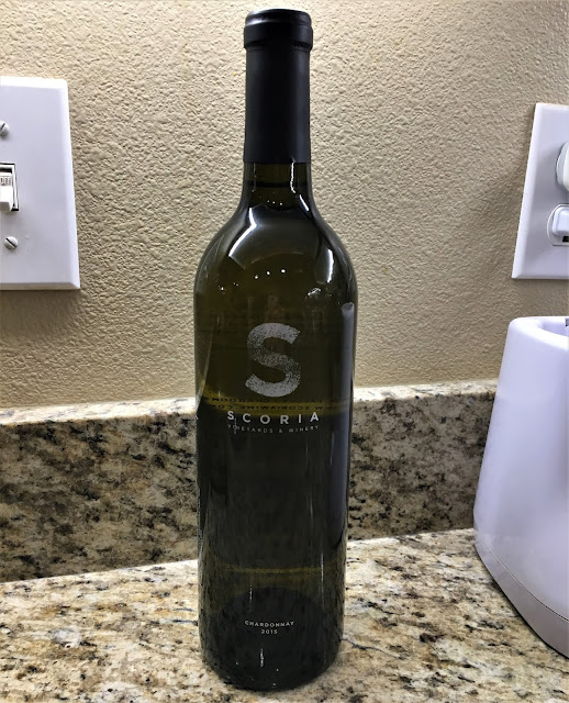
The next Drunk on Geology post is for the Scoria Chardonnay from the Scoria Vineyards and Winery

The Scoria Vineyards and Winery are located in the same region as the previous Drunk on Geology post, Cinder Wines, the Snake River Plain, and both even have geologically related names. The words "cinder" and "scoria" are often used interchangeably within the geological nomenclature. 

Scoria is a volcanic rock that solidifies as basaltic lava is splattered out of a volcanic vent. Lava is categorized by its chemical composition, which also effects other aspects of it. Basaltic magma is a low silica (quartz) magma, meaning it tends to have a low viscosity (runny), is darker in color (black), it has a high iron and magnesium content (rusts), and it is also generally hotter when it erupts. 

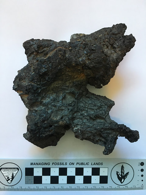
Sample of scoria from Utah's Ice Spings Volcano. 

When you get a specific type of volcanic eruption where the basaltic lava splatters out, the lave then cools in the air with lots of air holes in it. This gives the lava rock a holey, lightweight appearance, like pumice, but black in color (as seen in the picture above). Over time these scoria rocks pile up around the vent eventually creating what is known as a cinder cone volcano. Cinder, again, referring to the scoria rocks.  

Text from the back of the bottle:
"Scoria's chardonnay takes on subtle tropical fruit flavors with expansive finishes of vanilla and French oak.
Our vines root deep into soil laced with dark volcanic scoria rock."
Pathway of the Yellowstone Hotspot across Idaho. Image courtesy of the Digital Geology of Idaho.

Generally, the Scoria Vineyards and Winery are located within the Snake River Plain. This is a region where the Yellowstone Hotspot once passed through. In actuality, the hotspot didn't move but the North American plate passed over the hotspot, creating this string of volcanic eruptions. While the plate passed over the hotspot, the hotspot melted most of this passage and afterwards, this region sank down from the cooling. It is a noticeable plain, devoid of mountains like the surrounding regions. Later, when the western US started to expand, which produced the Basin and Range region, this valley was susceptible to expansion, pulling the plate apart here. That expansion, which thinned the North American crust, combined with the low lying valley, allowed the hotter mantle to heat up this region melting the upper crustal rocks. This produced a score of volcanoes within the valley, including many parts of the western US down through Arizona. 


These volcanic eruptions, many of which were cinder cones, layered the Snake River Plain with scoria deposits. Later lake and river deposits made this valley an extremely fertile region with well drained soil, perfect for vineyards. Hence the reason so many wineries are located within the Snake River Plain. 

Thursday, December 10, 2020

Drunk on Volcanology - Cinder Viognier


The next Drunk on Geology post is for Cinder Viognier from Cinder Wines

Cinder Wines is located in Idaho along the Snake River Plain, and it is a winery that does not shy away from it's geological origins. I was able to visit their tasting room up in Garden City, Idaho and it was fantastic. Unfortunately, the photos I ended up taking of the wines we got from there disappeared. Luckily, we did keep one of the bottles that we got because they were so cool, the Vognier seen above. We got two more wines from there but these (below) are the only pictures I had of those. This is a crop of a much larger picture showing all of the wines we had gotten from that trip. 

The word "cinder" refers to the geological rock known as scoria. Scoria is a basaltic volcanic rock that has a lot of air holes within it and is typically black in color. Think pumice, but black. When volcanoes erupt, they spit up lava. There are many different types of lava depending on the silica content of the lava. The higher the silica content, the thicker the lava. Basaltic lava has a very low silica content and therefore a low viscosity. This low viscosity lava will then be able to flow, like the lava rivers in Hawaii. Sometimes, basaltic volcanoes will erupt by spluttering their lava into the air. As the lava is shot into the air it solidifies and piles up alongside the volcanic vent. Over time these piles of scoria will pile high enough to become a cone, termed a cinder cone. 

Piece of scoria/cinder from the Utah's Ice Springs Volcano. 

Besides just having a low silica content, scoria also has a high iron and magnesium content. Once in contact with the surrounding air and water, this high iron content will sometimes rust, forming a reddish tinge to the rock. If the iron content is high enough, then the rock can turn very red, especially if broken down through erosion. The Cinder Wines tasting room had a lovely panel of scoria (cinder) from the local region (below). This panel mixes the rusted red scoria with the more typical black scoria. 

Scoria display at the Cinder Wines Tasting Room

The patterns depicted within the panel above is also what is artistically recreated on many of the bottles sold at the winery, as seen on the Viognier pictured.

Up close view of the cinder patterns on the bottle.

The geology of the Snake River Plain is complex and Cinder Wines fully embraces it, to the point that the developed a little handout with the geological history of the region. The Snake River Plain initially formed from the passage of the Yellowstone Hotspot over the region. The hotspot essentially melted the crust and produced several eruptions along the way. After the hotspot moved on (or more accurately after this part of the North American plate moved over it, since a hotspot doesn't move), the area of the Snake River Plain cooled off and collapsed down. This created a noticeable, large flat lying valley that lacked the mountains of the neighboring areas. Within this region of the Snake River Plain there also formed a lake within that depression left. This lake, called the ancient Lake Idaho, filled much of the valley shown in the images above. 

Pathway of the Yellowstone Hotspot across Idaho. Image courtesy of the Digital Geology of Idaho

Around this time, there was a subduction zone along the west coast of the United States where the Farallon Plate was subducting (going beneath) North America. This caused North America to be squeezed. However, most of the plate eventually went completely below North America. Because the plate was no longer pushing up against North America, the squeezing was reduced and North America expanded, like a compressed sponge being let go. The expansion of North America produced a region called the Basin and Range, which is an area of alternating valleys and mountains. This expansion also produced a thinning of the crust, which allowed for the hot mantle to melt the crustal rocks producing volcanoes. These volcanoes, which frequently consist of cinder cones, can be found all along the western US from Idaho down through Arizona and California. 


Eventually, ancient Lake Idaho drained out through an area known as Hell's Canyon, leaving behind its nutrient rich soils behind. The Snake and Boise Rivers then began to occupy the abandoned valley. However, that is not all. To the south was the historic Lake Bonneville, the predecessor to the Great Salt Lake. This lake was butting up against the glacial moraines (debris piles) to the south of the Snake River Plain. Eventually these moraines broke (at Red Rock Pass), and cataclysmic flooding of Lake Bonneville proceeded to remove most of the water of the lake through the Snake River Canyon. This flooding deepened the Snake River Canyon, eroded much of the material that was in the canyon, but also deposited a ton of sediment within the valley once the flooding had ceased.  


What remained behind was a region with a complex geological history, rich in nutrients from the lakes and flooding events, as well as a well drained soil from the presence of volcanic rocks. A perfect location for a geological based winery.

Sunday, November 15, 2020

Drunk on Volcanology - Fire Rock Pale Ale

The next up in our Drunk on Geology series is the Fire Rock Pale Ale from the Kona Brewing Company

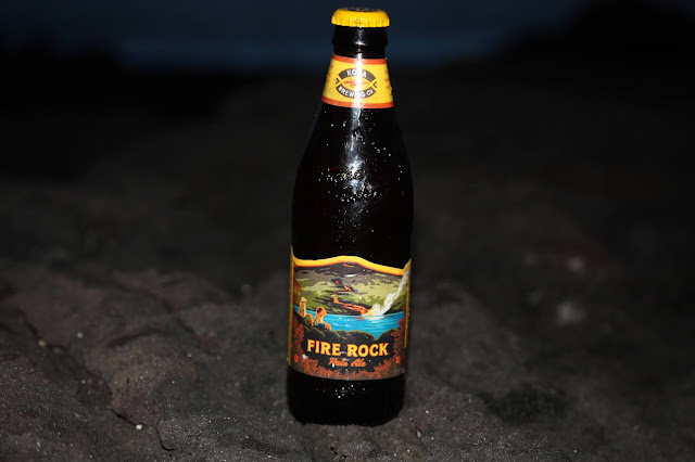
Like the Volcano Red I did previously, the Fire Rock is named in honor of the Hawaiian Island in which the brewery calls home. The imagery on the bottle depicts the basaltic lava flows characteristic of the Hawaiian Islands as the lava flows into the oceans. Basaltic lava is a fairly high temperature lava with a low silica content. Because of the higher temperatures and low silica content, this type of lava then has a low viscosity, meaning it flows very easily. On the opposite end of the spectrum is felsic lavas which have a high silica content, a lower temperature, and a high viscosity. The high viscosity lavas lead to volcanoes that are steep sided and tend to get plugged up by their own lava flows. These are type of volcanoes most people associate as a volcano, with its stereotypical conical shape. The felsic volcanoes also produce the more explosive eruptions, while the basaltic volcanoes, such as these on Hawaii, are rarely explosive. 

The much lower viscosity basaltic lavas are not able to create a steep sided volcano. So even though the pictured volcano is conical in shape, typical Hawaiian Island volcanoes are much more laid out with a slight curvature. This curvature is what gives this volcano type its name, shield volcano. 

Graphic depiction of the Hawaiian hotspot. Image courtesy of Clark Science.


All of the islands of Hawaii are actually volcanoes, with only the Big Island having active volcanoes on it. Hawaii is a special type of volcano known as a hotspot. A hotspot is a type of volcano that sits in one place as the crustal plate on the surface of the Earth rides over it. The source of the magma for a hotspot is an area known as a mantle plume. This spot is essentially "fixed" within the Earth and doesn't move while the plates on the Earth's surface are all moving around on top of it. As the plate moves, the Pacific Plate in this instance, over the hotspot, volcanoes pop up out of the sea floor. As the plate continues to move on, the old volcanoes are pulled away from the hotspot source and die off, while new volcanoes are created. 

Text from one side of the bottle neck:
"Active volcanoes on the Big Island of Hawaii leave visitors awestruck by their power. The glow of lava as it meets the ocean is an amazing sight."
On the Big Island there are actually five subaerial volcanoes, of which three are considered active (last erupted in the last 10,000 years): Kilauea, Mauna Loa, and Hualalai. When we had visited the Big Island at the beginning of April in 2018, the glow of the lava, giving the "Fire Rock" its name, could easily be seen within two parts of Kilauea. Here in the main crater, named Halema'uma'u Crater and ...

...and here at the Pu‘U ‘Ō‘Ō crater further to the west along the flanks of Kilauea. 

Text from the other side of the bottle neck:
"Our Fire Rock Pale Ale is inspired by this place with a bright copper color and rich roasted malt taste. Aloha!"

Since we were staying the beaches in Kailua-Kona, I was able to get a picture of the Fire Rock Pale Ale along some of Hualalai's lava flows, the same lava flows that the brewery is located upon. Hualalai volcano last erupted from 1800 to 1801, however the volcano started erupting 800,000 years ago and breached the surface of the ocean around 300,000 years ago. The lava flows that underlay the city of Kailua-Kona range in age from 5,000 to 13,000 years old, however with lava flows from the volcano just over 200 years old indicates that this volcano is very much still active. This last, and only historical lava flow, was witnessed by one of Captain Cook's crew who remained on the island. 

References